Big Sur
3 days in classic California
This spontaneous trip was my final camping trip of college. I did a bit of research online beforehand, but for the most part we just showed up and hoped for the best. Note: there is an area officially called Big Sur State Park, but during this trip I call the nearby coastline and surrounding parks Big Sur also.
Day 1
The one crucial bit of info I learned beforehand were the details about Kirk Creek Campground. There are campgrounds all over the place in Big Sur, but many are overpriced and on the days we were visiting they were fully booked. However, there are numerous first-come, first-serve basic campgrounds in the southern part of Big Sur, with Kirk Creek Campground being the best. Sunset Magazine rated the campground as the sixth best in the West, as detailed here. It’s technically in the Los Padres National Forest and is about 35 mins from the heart of Big Sur, but it is AMAZING. It is a collection of 30 sites that sit on the edge of a cliff with amazing views of the coastline, ocean, and sunset. Easily one of the best campsites of my life.

We snagged a great site by arriving at 8:30am, just as people on Yelp suggested. It also helped that we arrived on a Thursday morning instead of Friday or Saturday. One small downside is that there is no fresh water, but we knew that and planned ahead. The view is definitely a fair tradeoff for no water.
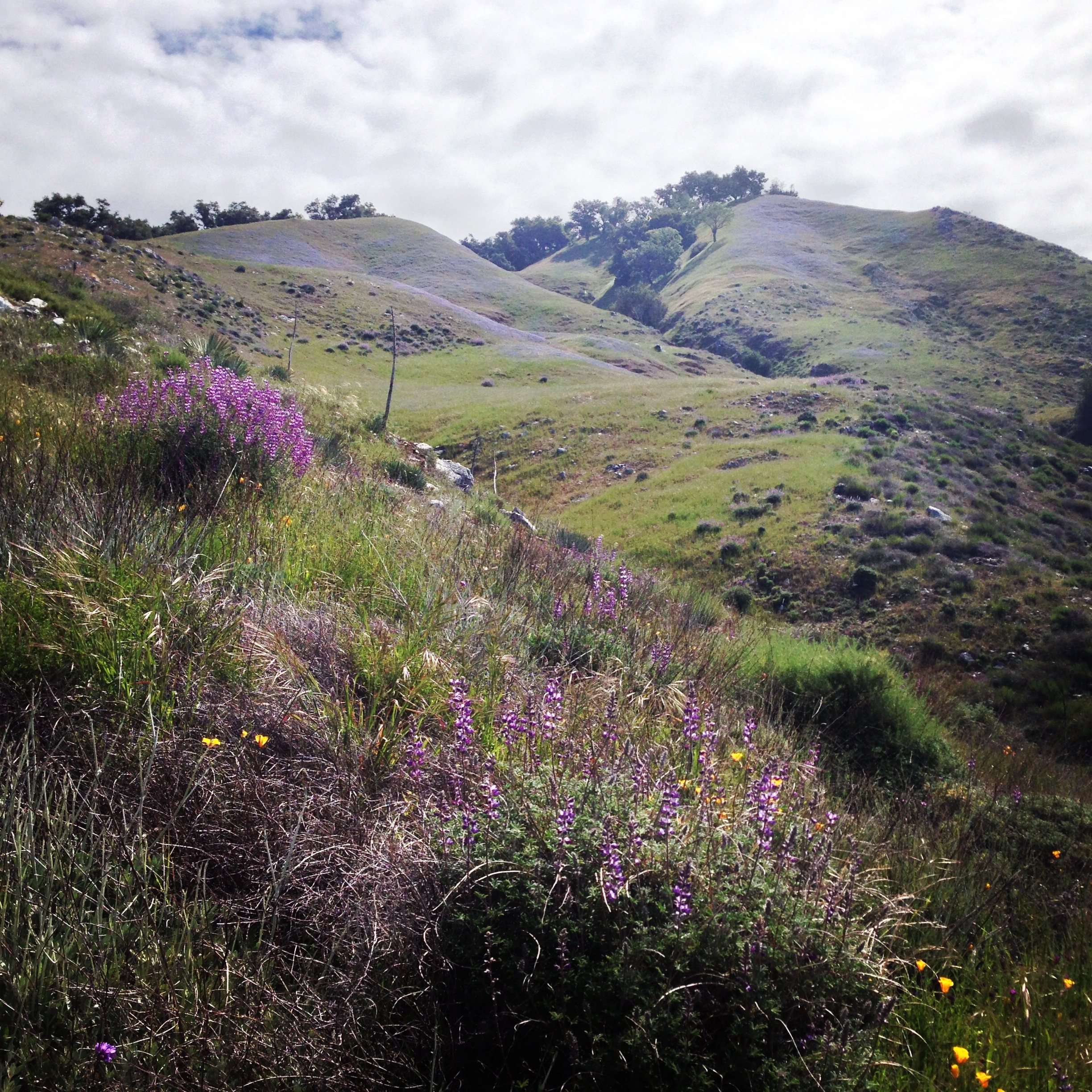
Since we arrived so early, we had the whole day ahead of us to start hiking and exploring. We started by packing up some Trader Joe’s snacks and walking across Hwy 1 to reach a trail that we believe was the Vincente Flats trail. (Trail markers were rare or nonexistent on this whole trip.) We climbed the trail quite a bit until we were about ¾ of the way up the coastal mountains. Then the trail leveled off and we wound around the hills for a while. The whole time we had a great view of the coastline, with spontaneous patches of wildflowers. My favorite picture of the flowers is the one at the top of this post, and a picture of the view from the trail is below.

After hiking about 4 miles in, we decided that we’d had enough and turned back. There wasn’t any big destination endpoint, but the trail was beautiful and almost completely empty.
Next, we drove over to the tiny Limekiln State Park, just a few miles north. We took a couple short hikes (maybe .3 miles each?) to a couple destinations: a small waterfall, some old lime kilns from the late 1800’s, and a small beach. Nothing too special here, but it was a nice spot and had easy, relaxing walks. I’d call it a good picnic spot, but not a big destination.
At the end of our first day we drove down to Sand Dollar beach, a few miles south. It was a huge beach tucked in a cove, and had some great overlooks. We rested here for a while, then headed back to our picturesque camp for some fire-roasted sausages, chili, and beers. A great start to the trip.

Day 2
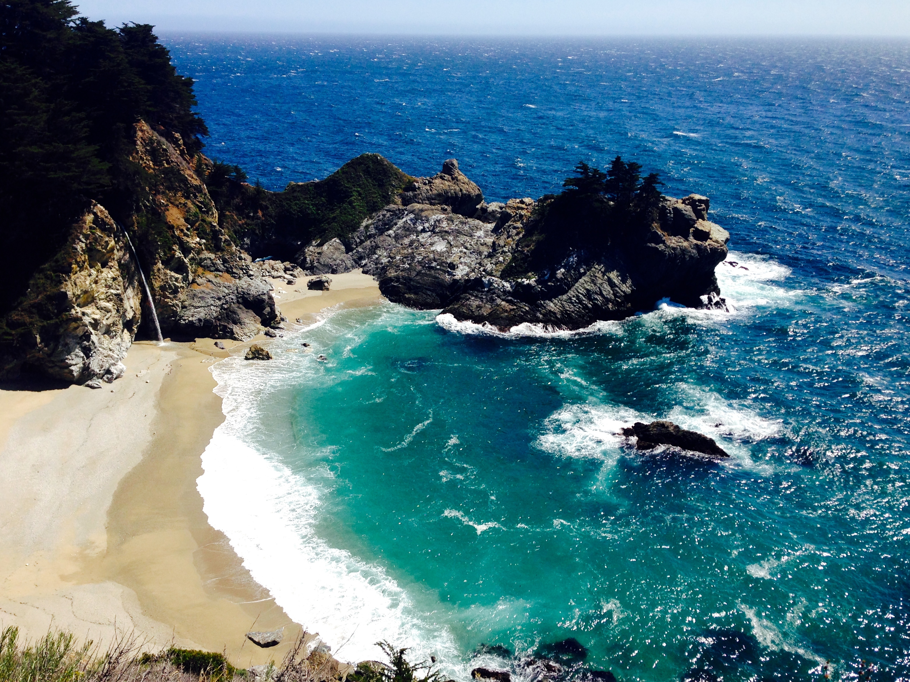
Day 2! We powered up with some apple muffins, then headed further north to Julia Pfeiffer State Park. The main attraction here is a cove near the highway with McWay Falls pouring into it. The falls was spectacular and easily accessible, so therefore it was also packed with people. Even though it was a .4 mile flat trail to the overlook, I still had people ask me, “Can I take a picture of the falls from my car?”. Nonetheless, the cove and falls were surreal. I hope the photo captures some of that.
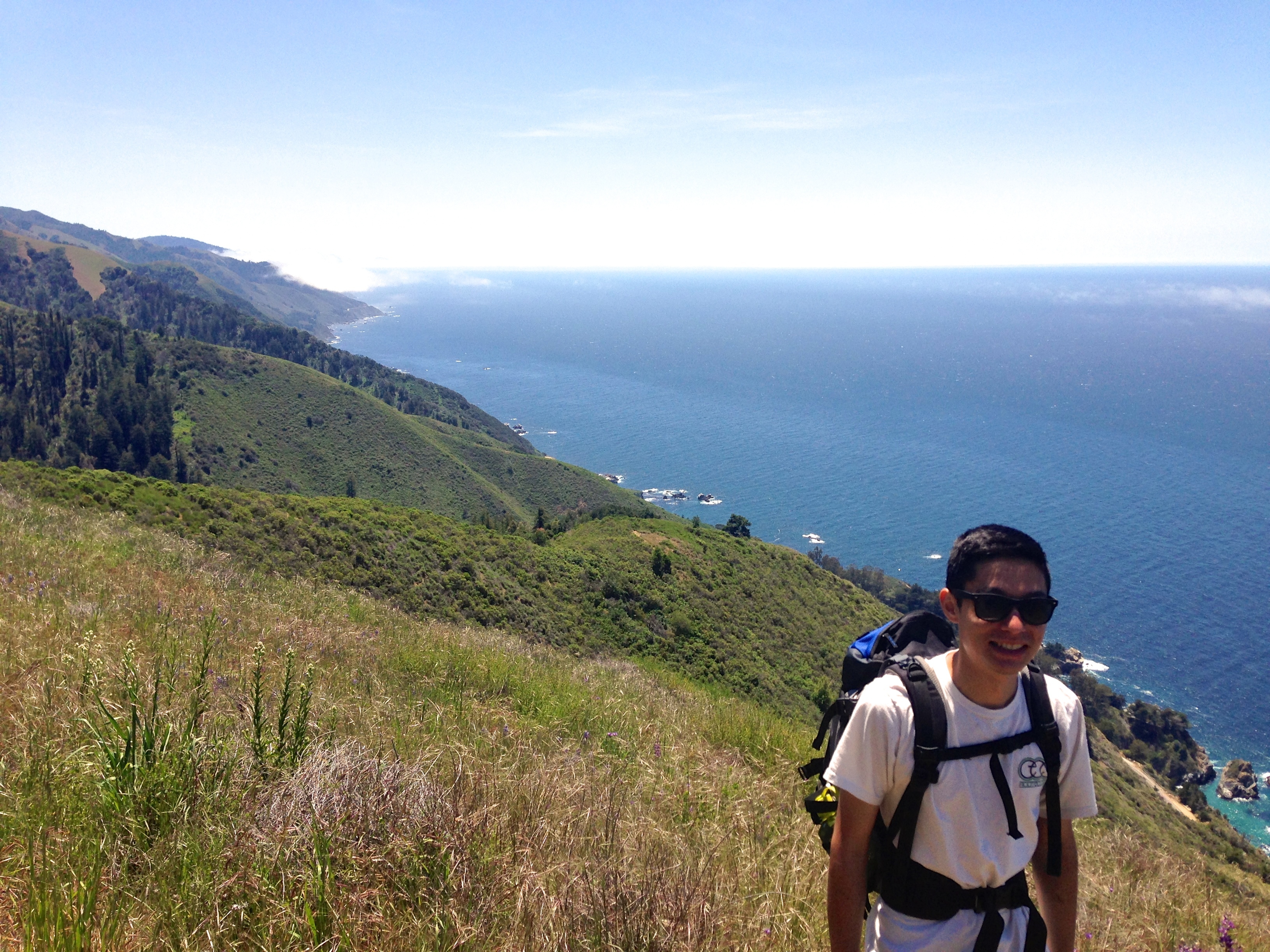
After gaping at the falls for a while, we headed over to the inland side of the park and hiked the Ewoldson Trail. It was around 8 miles total, and again went up into the mountains, displaying amazing views of the coast. There were MANY snakes when we went on this trail, but all of them were harmless gopher snakes I believe. Still, it was really startling to have snakes slither away into the tall grass as you hike through a meadow. Midway up the mountain we found the best meadow of wildflowers EVER. We took a long break here, ate a lot of dried mango slices, and took some nice photos.

We continued up the mountain and saw even more striking views of the coast. I don’t know how many amazing views a person can soak in, but we definitely got our fair share on this trip. We ended up finding a trail map at the top of the mountain, 4 miles in, that showed two trails that connected to ours. However, we were fairly tired and uncertain about the length of the other trails so we headed back the way we came.
For the last little bit of the day, we headed barely a mile north of Julia Pfeiffer to a small turnout and hiked down to a cove. We didn’t expect to see much, but we sat around on the rocky beach for a while and saw an otter! I was hoping to see one on this trip, and was really excited to see the little otter pop out of the water and float on its belly. Unfortunately, it was too far away to get a photo. You’ll just have to go see one for yourself.
Day 3
On this final day, we packed up camp and headed far north to the true Pfeiffer Big Sur State Park. It’s at the far northern end of this large area of state parks and forests that we visited on this trip. Truthfully, Pfeiffer Big Sur was a bit of a let down. There were many more visitors here and the main attractions of a waterfall and valley viewpoint weren’t very exciting after the sights of the previous two days. We probably finished our visit in 45 minutes and then headed a couple miles north to Andrew Molera State Park. By contrast, this park seemed very large, open, and beautiful. We chose to do an 8 mile loop that followed the mountain ridge line, then followed the coast down to a beach. In the first five minutes of the hike, we came upon an unexpected river crossing. It was actually really fun and refreshing to take off our shoes and wade across the small river. (It was also good to wash our feet a bit.) We hiked through a meadow and up along a ridge, which provided excellent views. I have to say that my photos don’t really capture the scene here well.

The ridge part of the trail ended at Panoramic Point which, unsurprisingly, made a great panorama. It was extremely windy here, so we quickly headed down toward the coast. There were a couple points of interest along the way: we crawled through a tree tunnel, went to a pink/purple sand beach, and walked through trees covered in flowers. The endpoint was a popular beach with hikers, families, picnickers, surfers, and partiers. There were a couple driftwood forts there, but those were all claimed by other groups to protect themselves from the wind. From there, we had to do one more river crossing and then headed home from a successful trip.
Overall, this was a really awesome trip and I highly recommend Big Sur for car camping or backpacking. I definitely want to go back to Kirk Creek in the future for that sunset:
